Download
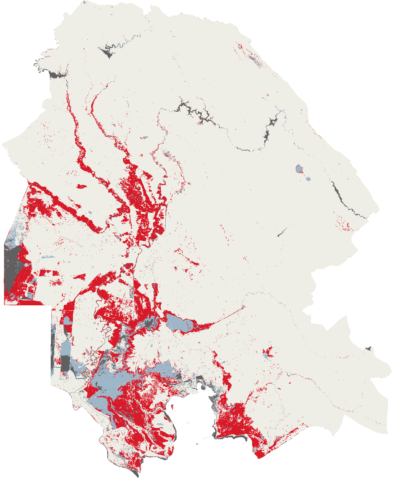
The three flood map layers of Khuzestan, spring 2019
The map layers of the page as rasters a reader can open in a geographic information system. Every cell holds the class the map draws it as.
Format: Cloud Optimised GeoTIFF
Coverage: Khuzestan province, Iran, on a 20 m grid in EPSG:6933, for 15 March to 7 June 2019, the hybrid map over the whole span.
Licence: CC-BY-4.0
Files
- flood_extent.tif 4.2 MB
1 flood, 2 water before the rain, 3 not mapped, 4 judged and dry, 253 permanent water, 255 outside the province, for the hybrid map of 15 March to 7 June 2019
- optical_2019-03-27.tif 3.6 MB
0 not observed, 1 observed and dry, 2 flood, 3 standing water, 4 baseline unknown, 5 permanent water, 255 outside the province, for the optical date 2019-03-27
- optical_2019-04-08.tif 3.7 MB
0 not observed, 1 observed and dry, 2 flood, 3 standing water, 4 baseline unknown, 5 permanent water, 255 outside the province, for the optical date 2019-04-08
- optical_2019-04-11.tif 3.1 MB
0 not observed, 1 observed and dry, 2 flood, 3 standing water, 4 baseline unknown, 5 permanent water, 255 outside the province, for the optical date 2019-04-11
- optical_2019-04-17.tif 2.9 MB
0 not observed, 1 observed and dry, 2 flood, 3 standing water, 4 baseline unknown, 5 permanent water, 255 outside the province, for the optical date 2019-04-17
- optical_2019-04-21.tif 3.2 MB
0 not observed, 1 observed and dry, 2 flood, 3 standing water, 4 baseline unknown, 5 permanent water, 255 outside the province, for the optical date 2019-04-21
- optical_2019-04-23.tif 3.2 MB
0 not observed, 1 observed and dry, 2 flood, 3 standing water, 4 baseline unknown, 5 permanent water, 255 outside the province, for the optical date 2019-04-23
- optical_2019-04-26.tif 3.1 MB
0 not observed, 1 observed and dry, 2 flood, 3 standing water, 4 baseline unknown, 5 permanent water, 255 outside the province, for the optical date 2019-04-26
- optical_2019-05-03.tif 2.4 MB
0 not observed, 1 observed and dry, 2 flood, 3 standing water, 4 baseline unknown, 5 permanent water, 255 outside the province, for the optical date 2019-05-03
- optical_2019-05-13.tif 2.2 MB
0 not observed, 1 observed and dry, 2 flood, 3 standing water, 4 baseline unknown, 5 permanent water, 255 outside the province, for the optical date 2019-05-13
- optical_2019-06-07.tif 2.1 MB
0 not observed, 1 observed and dry, 2 flood, 3 standing water, 4 baseline unknown, 5 permanent water, 255 outside the province, for the optical date 2019-06-07
- radar_window_1.tif 12.9 MB
1 flood, 2 standing water floor, 3 excluded, 4 not observed in the window, 5 observed and dry, 253 permanent water, 255 outside the province, for the 12-day window 1 of seven
- radar_window_2.tif 13 MB
1 flood, 2 standing water floor, 3 excluded, 4 not observed in the window, 5 observed and dry, 253 permanent water, 255 outside the province, for the 12-day window 2 of seven
- radar_window_3.tif 12.7 MB
1 flood, 2 standing water floor, 3 excluded, 4 not observed in the window, 5 observed and dry, 253 permanent water, 255 outside the province, for the 12-day window 3 of seven
- radar_window_4.tif 12.8 MB
1 flood, 2 standing water floor, 3 excluded, 4 not observed in the window, 5 observed and dry, 253 permanent water, 255 outside the province, for the 12-day window 4 of seven
- radar_window_5.tif 12.8 MB
1 flood, 2 standing water floor, 3 excluded, 4 not observed in the window, 5 observed and dry, 253 permanent water, 255 outside the province, for the 12-day window 5 of seven
- radar_window_6.tif 12.6 MB
1 flood, 2 standing water floor, 3 excluded, 4 not observed in the window, 5 observed and dry, 253 permanent water, 255 outside the province, for the 12-day window 6 of seven
- radar_window_7.tif 12.6 MB
1 flood, 2 standing water floor, 3 excluded, 4 not observed in the window, 5 observed and dry, 253 permanent water, 255 outside the province, for the 12-day window 7 of seven
Classes
Hybrid map, 15 March to 7 June: flood_extent.tif
- 0 unset, not drawn
- 1 flood
- 2 water before the rain
- 3 not mapped
- 4 judged and dry, not drawn
- 253 permanent water, not drawn
- 255 outside the province, not drawn
Optical map: optical_2019-03-27.tif, optical_2019-04-08.tif, optical_2019-04-11.tif, optical_2019-04-17.tif, optical_2019-04-21.tif, optical_2019-04-23.tif, optical_2019-04-26.tif, optical_2019-05-03.tif, optical_2019-05-13.tif, optical_2019-06-07.tif
- 0 not mapped
- 1 observed and dry, not drawn
- 2 flood
- 3 water before the rain
- 4 not mapped
- 5 permanent water, not drawn
- 255 outside the province, not drawn
GFM radar: radar_window_1.tif, radar_window_2.tif, radar_window_3.tif, radar_window_4.tif, radar_window_5.tif, radar_window_6.tif, radar_window_7.tif
- 0 unset, not drawn
- 1 flood
- 2 water before the rain
- 3 not mapped
- 4 not mapped
- 5 observed and dry, not drawn
- 253 permanent water, not drawn
- 255 outside the province, not drawn
Attribution
- Boundaries from geoBoundaries, William and Mary geoLab, Open Database Licence 1.0
- Contains modified Copernicus Emergency Management Service information, Global Flood Monitoring (2019)
- Contains modified Copernicus information, EC JRC Global Surface Water (Pekel et al., 2016)
- Contains modified Copernicus Sentinel data 2019
Derived from
- geoBoundaries Iran, ADM1 and ADM2, geoBoundaries, William and Mary geoLab, version 9469f09, ODbL-1.0
- Copernicus Global Flood Monitoring over Khuzestan, 15 March to 14 June 2019, Copernicus Emergency Management Service, processed and hosted by EODC, version 2026-09-13, Copernicus free, full and open (Regulation (EU) No 1159/2013)
- JRC Global Surface Water, monthly history, European Commission Joint Research Centre, version ver5-0, CC-BY-4.0
- JRC Global Surface Water, seasonality, European Commission Joint Research Centre, version v1-4-2021, Copernicus free, full and open (Regulation (EU) No 1159/2013)
- Landsat 8 Collection 2 Level-2 over Khuzestan, four dates of 2019, United States Geological Survey, hosted by Microsoft Planetary Computer, version 2026-09-15, public domain, United States Geological Survey
- Sentinel-2 Collection 1 Level-2A over Khuzestan, eleven dates of 2019, European Space Agency, Collection 1 reprocessing, hosted by Element 84, version 2026-09-15, Copernicus free, full and open (Regulation (EU) No 1159/2013)